
Doe een donatie
Rust jezelf uit voor je volgende avontuur:
Als Amazon-partner verdient deze site een commissie op in aanmerking komende aankopen, zonder extra kosten voor jou.
Topografische kaart Sylt
Klik op de kaart om de hoogte weer te geven.
Doe een donatie
Rust jezelf uit voor je volgende avontuur:
Als Amazon-partner verdient deze site een commissie op in aanmerking komende aankopen, zonder extra kosten voor jou.
Sylt
The island's shape has constantly shifted over time, a process which is still ongoing today. The northern and southern spits of Sylt are exclusively made up of infertile sand deposits, while the central part with the municipalities of Westerland, Wenningstedt-Braderup and Sylt-Ost consists of a geestland core, which becomes apparent in the form of the Red Cliff of Wenningstedt. The geestland facing the Wadden Sea gradually turns into fertile marshland around Sylt-Ost. Sylt has only been an island since the Grote Mandrenke flood of 1362. The so-called Uwe-Düne (Uwe Dune) is the island's highest elevation with 52.5 metres (172.2 feet) above sea level.
Doe een donatie
Rust jezelf uit voor je volgende avontuur:
Als Amazon-partner verdient deze site een commissie op in aanmerking komende aankopen, zonder extra kosten voor jou.
Over deze kaart
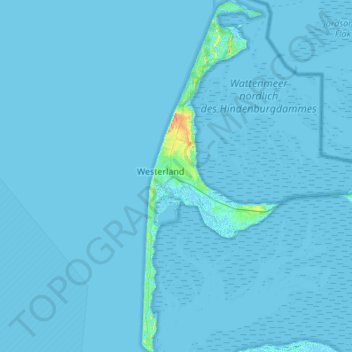
Naam: Topografische kaart Sylt, hoogte, reliëf.
Locatie: Sylt, Northern Friesland, Schleswig-Holstein, Germany (54.74589 8.27846 55.05866 8.48996)
Gemiddelde hoogte: 0 m
Minimale hoogte: -3 m
Maximale hoogte: 35 m
Doe een donatie
Rust jezelf uit voor je volgende avontuur:
Als Amazon-partner verdient deze site een commissie op in aanmerking komende aankopen, zonder extra kosten voor jou.
Andere topografische kaarten
Klik op een kaart om zijn topografie, zijn hoogte en zijn reliëf te bekijken.