
Doe een donatie
Rust jezelf uit voor je volgende avontuur:
Als Amazon-partner verdient deze site een commissie op in aanmerking komende aankopen, zonder extra kosten voor jou.
Topografische kaart Cluj-Napoca
Klik op de kaart om de hoogte weer te geven.
Doe een donatie
Rust jezelf uit voor je volgende avontuur:
Als Amazon-partner verdient deze site een commissie op in aanmerking komende aankopen, zonder extra kosten voor jou.
Cluj-Napoca
A wide variety of flora grow in the Cluj-Napoca Botanical Garden; some animals have also found refuge there. The city has a number of other parks, of which the largest is the Central Park. This park was founded during the 19th century and includes an artificial lake with an island, as well as the largest casino in the city, Chios. Other notable parks in the city are the Iuliu Hațieganu Park of the Babeș-Bolyai University, which features some sport facilities, the Hașdeu Park, within the eponymous student housing district, the high-elevation Cetățuia, and the Opera Park, behind the building of the Cluj-Napoca Romanian Opera.
Doe een donatie
Rust jezelf uit voor je volgende avontuur:
Als Amazon-partner verdient deze site een commissie op in aanmerking komende aankopen, zonder extra kosten voor jou.
Over deze kaart
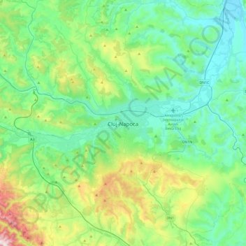
Naam: Topografische kaart Cluj-Napoca, hoogte, reliëf.
Locatie: Cluj-Napoca, Cluj, 400133, Romania (46.60938 23.42995 46.92938 23.74995)
Gemiddelde hoogte: 490 m
Minimale hoogte: 274 m
Maximale hoogte: 1.207 m
Doe een donatie
Rust jezelf uit voor je volgende avontuur:
Als Amazon-partner verdient deze site een commissie op in aanmerking komende aankopen, zonder extra kosten voor jou.