
Doe een donatie
Rust jezelf uit voor je volgende avontuur:
Als Amazon-partner verdient deze site een commissie op in aanmerking komende aankopen, zonder extra kosten voor jou.
Topografische kaart Bountiful
Klik op de kaart om de hoogte weer te geven.
Doe een donatie
Rust jezelf uit voor je volgende avontuur:
Als Amazon-partner verdient deze site een commissie op in aanmerking komende aankopen, zonder extra kosten voor jou.
Over deze kaart
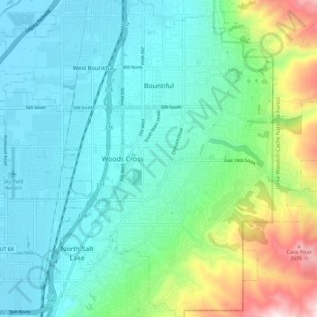
Naam: Topografische kaart Bountiful, hoogte, reliëf.
Locatie: Bountiful, Davis County, Utah, 84010, United States (40.83291 -111.90212 40.91028 -111.81538)
Gemiddelde hoogte: 1.477 m
Minimale hoogte: 1.280 m
Maximale hoogte: 2.160 m
Doe een donatie
Rust jezelf uit voor je volgende avontuur:
Als Amazon-partner verdient deze site een commissie op in aanmerking komende aankopen, zonder extra kosten voor jou.
Andere topografische kaarten
Klik op een kaart om zijn topografie, zijn hoogte en zijn reliëf te bekijken.
Antelope Island
United States > Utah > Davis County
The island is accessible via a 7-mile causeway from Syracuse in Davis County. Access from Interstate 15 is via exit 332, then west along Antelope Drive (SR-108). The island's shore (all but west side of the island) is mostly flat with beaches and plains to the base of the mountains on the island. These steep…
Gemiddelde hoogte: 1.306 m
Doe een donatie
Rust jezelf uit voor je volgende avontuur:
Als Amazon-partner verdient deze site een commissie op in aanmerking komende aankopen, zonder extra kosten voor jou.
Doe een donatie
Rust jezelf uit voor je volgende avontuur:
Als Amazon-partner verdient deze site een commissie op in aanmerking komende aankopen, zonder extra kosten voor jou.
Mount Lebannon Acres
United States > Utah > Davis County > Centerville > Rosedale
Gemiddelde hoogte: 1.464 m