
Topografische kaart Colachel
Interactieve kaart
Klik op de kaart om de hoogte weer te geven.
Over deze kaart
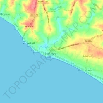
Naam: Topografische kaart Colachel, hoogte, reliëf.
Gemiddelde hoogte: 16 m
Minimale hoogte: -1 m
Maximale hoogte: 72 m
The town is located on the western coastal side of Kanyakumari District and falls in the coordinates of 8°09′N 77°08′E / 8.15°N 77.14°E / 8.15; 77.14. The average elevation of the town is 25 meters (82 ft) above Mean Sea Level (MSL). Town is mostly characterized by a flat terrain with a few areas in the northwest region having elevation difference with other parts of the town. Generally the town is sloped gently from North to south direction and also sloping in a radial direction towards centre portion of the town from east and west directions.
Andere topografische kaarten
Klik op een kaart om zijn topografie, zijn hoogte en zijn reliëf te bekijken.
Kumarapuram
India > Tamil Nadu > Kalkulam
Kumarapuram, Kalkulam, Kanniyakumari District, Tamil Nadu, 629166, India
Gemiddelde hoogte: 76 m
Aloor
India > Tamil Nadu > Kalkulam
Aloor, Kalkulam, Kanyakumari District, Tamil Nadu, 629809, India
Gemiddelde hoogte: 41 m
Kalkulam
India > Tamil Nadu > Kalkulam
Kalkulam, Kanyakumari District, Tamil Nadu, India
Gemiddelde hoogte: 245 m