
Topografische kaart Ανάβυσσος
Interactieve kaart
Klik op de kaart om de hoogte weer te geven.
Over deze kaart
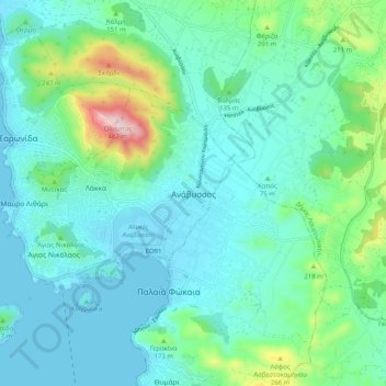
Naam: Topografische kaart Ανάβυσσος, hoogte, reliëf.
Gemiddelde hoogte: 91 m
Minimale hoogte: -8 m
Maximale hoogte: 479 m
Andere topografische kaarten
Klik op een kaart om zijn topografie, zijn hoogte en zijn reliëf te bekijken.
Astypalaia
Greece > Attica > Regional Unit of East Attica > Anavissos Municipal Unit
Astypalaia, Anavissos Municipal Unit, Municipality of Saronikos, Regional Unit of East Attica, Attica, 190 13, Greece
Gemiddelde hoogte: 10 m