
Doe een donatie
Rust jezelf uit voor je volgende avontuur:
Als Amazon-partner verdient deze site een commissie op in aanmerking komende aankopen, zonder extra kosten voor jou.
Topografische kaart Jim Smith Lake
Klik op de kaart om de hoogte weer te geven.
Doe een donatie
Rust jezelf uit voor je volgende avontuur:
Als Amazon-partner verdient deze site een commissie op in aanmerking komende aankopen, zonder extra kosten voor jou.
Over deze kaart
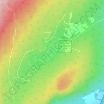
Naam: Topografische kaart Jim Smith Lake, hoogte, reliëf.
Gemiddelde hoogte: 1.091 m
Minimale hoogte: 975 m
Maximale hoogte: 1.229 m
Doe een donatie
Rust jezelf uit voor je volgende avontuur:
Als Amazon-partner verdient deze site een commissie op in aanmerking komende aankopen, zonder extra kosten voor jou.
Andere topografische kaarten
Klik op een kaart om zijn topografie, zijn hoogte en zijn reliëf te bekijken.
Fort Steele
Canada > British Columbia > Regional District of East Kootenay > Area C (Moyie/Bull River)
Gemiddelde hoogte: 797 m
Wardner
Canada > British Columbia > Regional District of East Kootenay > Area C (Moyie/Bull River)
Gemiddelde hoogte: 815 m
Bull Mountain
Canada > British Columbia > Regional District of East Kootenay > Area C (Moyie/Bull River)
Gemiddelde hoogte: 2.068 m
Moyie Lake
Canada > British Columbia > Regional District of East Kootenay > Area C (Moyie/Bull River) > Moyie
Gemiddelde hoogte: 1.185 m
Doe een donatie
Rust jezelf uit voor je volgende avontuur:
Als Amazon-partner verdient deze site een commissie op in aanmerking komende aankopen, zonder extra kosten voor jou.
Moyie
Canada > British Columbia > Regional District of East Kootenay > Area C (Moyie/Bull River)
Gemiddelde hoogte: 1.164 m
Mount Bisaro
Canada > British Columbia > Regional District of East Kootenay > Area C (Moyie/Bull River)
Gemiddelde hoogte: 2.115 m