Geolokaliseren
👉 Easily get elevation data in JSON, GeoTIFF and KML formats using Elevation API
Bedankt voor het steunen van deze site ❤️
Doe een donatie

Topografische kaart Nashik

Klik op de kaart om de hoogte weer te geven.

👉 Easily get elevation data in JSON, GeoTIFF and KML formats using Elevation API
Bedankt voor het steunen van deze site ❤️
Doe een donatie

Nashik

The city's tropical location and high altitude combine to give it a relatively mild version of a tropical wet and dry climate (Köppen Aw). Temperatures rise slightly in October, but this is followed by the cool season from November to February. The cool season sees warm temperatures of around 28 °C or 82.4 °F during the day, but cool nights, with lows averaging 10 °C or 50 °F, and extremely dry air.

Wikipedia (CC-BY-SA 3.0)

Over deze kaart

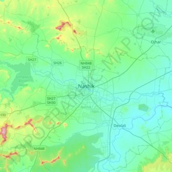
Naam: Topografische kaart Nashik, hoogte, reliëf.

Locatie: Nashik, Nashik Taluka, Nashik District, Maharashtra, 422001, India (19.85125 73.63024 20.17125 73.95024)

Gemiddelde hoogte: 631 m

Minimale hoogte: 535 m

Maximale hoogte: 1.079 m

Rust jezelf uit voor je volgende avontuur:

🧤Outdoor Handschoenen - Bescherming tegen kou en wind tijdens hikes
🔋Oplaadbare Batterijen - Power voor je zaklamp of GPS-toestel
🧴Blarenpleisters - Directe verlichting bij wrijving
📘Outdoor Handleidingen - Praktische kennis voor avonturiers
📱Outdoor GPS Trackers - Volg routes en prestaties

Als Amazon-partner verdient deze site een commissie op in aanmerking komende aankopen, zonder extra kosten voor jou.