
Topografische kaart Inyo County
Interactieve kaart
Klik op de kaart om de hoogte weer te geven.
Over deze kaart
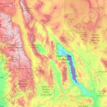
Naam: Topografische kaart Inyo County, hoogte, reliëf.
Locatie: Inyo County, California, United States of America (35.78658 -118.79005 37.46493 -115.64806)
Gemiddelde hoogte: 1.473 m
Minimale hoogte: -83 m
Maximale hoogte: 4.242 m
Mount Whitney, the highest peak in the contiguous United States, is on Inyo County's western border (with Tulare County). The Badwater Basin in Death Valley National Park, the lowest place in North America, is in eastern Inyo County. The difference between the two points is about 14,700 feet (4,500 m). They are not visible from each other, but both can be observed from the Panamint Range on the west side of Death Valley, above the Panamint Valley. Thus, Inyo County has the greatest elevation difference among all of the counties and county-equivalents in the contiguous United States.
Andere topografische kaarten
Klik op een kaart om zijn topografie, zijn hoogte en zijn reliëf te bekijken.
Alpine County
United States of America > California
Alpine County, California, United States of America
Gemiddelde hoogte: 2.216 m
Mariposa County
United States of America > California
Mariposa County, California, United States of America
Gemiddelde hoogte: 1.036 m
Humboldt County
United States of America > California
Humboldt County, California, United States of America
Gemiddelde hoogte: 540 m
San Diego County
United States of America > California
San Diego County, California, United States of America
Gemiddelde hoogte: 544 m
Lake County
United States of America > California
Lake County, California, United States of America
Gemiddelde hoogte: 550 m
Kings County
United States of America > California
Kings County, California, United States of America
Gemiddelde hoogte: 101 m
Owens Lake
United States of America > California
Owens Lake, Inyo County, California, United States of America
Gemiddelde hoogte: 1.281 m
Zimba
United States of America > California
Zimba, Stanislaus County, California, United States of America
Gemiddelde hoogte: 594 m
Sutter County
United States of America > California
Sutter County, California, United States of America
Gemiddelde hoogte: 30 m
Newport Beach
United States of America > California > Newport Beach > Newport Beach
Newport Beach, Orange, California, United States of America
Gemiddelde hoogte: 14 m
Alameda County
United States of America > California
Alameda County, California, United States of America
Gemiddelde hoogte: 219 m
Volcano
United States of America > California > Volcano
Volcano, Amador, California, 95689, United States of America
Gemiddelde hoogte: 726 m
Mono County
United States of America > California
Mono County, California, United States of America
Gemiddelde hoogte: 2.175 m
Santa Cruz County
United States of America > California
Santa Cruz County, California, United States of America
Gemiddelde hoogte: 191 m
Santa Clara County
United States of America > California
Santa Clara County, California, United States of America
Gemiddelde hoogte: 323 m
Siskiyou County
United States of America > California
Siskiyou County, California, United States of America
Gemiddelde hoogte: 1.187 m