
Topografische kaart Zahedan
Interactieve kaart
Klik op de kaart om de hoogte weer te geven.
Over deze kaart
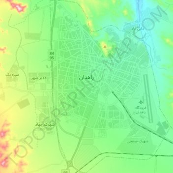
Naam: Topografische kaart Zahedan, hoogte, reliëf.
Gemiddelde hoogte: 1.416 m
Minimale hoogte: 1.307 m
Maximale hoogte: 1.721 m
Zahedan is connected by rail to nearby Pakistan and is near to Afghanistan. It is about 41 km (25 mi) south of the tripoint of the three countries and at an altitude of 1,352 m (4,436 ft) above sea level and 1,605 km (997 mi) from the Iranian capital of Tehran.