
Topografische kaart Washington County
Interactieve kaart
Klik op de kaart om de hoogte weer te geven.
Over deze kaart
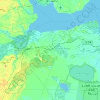
Naam: Topografische kaart Washington County, hoogte, reliëf.
Locatie: Washington County, North Carolina, United States of America (35.69759 -76.84512 36.02636 -76.35365)
Gemiddelde hoogte: 4 m
Minimale hoogte: -2 m
Maximale hoogte: 25 m
Andere topografische kaarten
Klik op een kaart om zijn topografie, zijn hoogte en zijn reliëf te bekijken.
Chatham County
United States of America > North Carolina
Chatham County, North Carolina, United States of America
Gemiddelde hoogte: 132 m
Lincoln County
United States of America > North Carolina
Lincoln County, North Carolina, United States of America
Gemiddelde hoogte: 266 m
Kannapolis
United States of America > North Carolina > Kannapolis
Kannapolis, Cabarrus County, North Carolina, United States of America
Gemiddelde hoogte: 222 m
Forsyth County
United States of America > North Carolina
Forsyth County, North Carolina, United States of America
Gemiddelde hoogte: 258 m
Alamance County
United States of America > North Carolina
Alamance County, North Carolina, United States of America
Gemiddelde hoogte: 194 m
Rockingham County
United States of America > North Carolina
Rockingham County, North Carolina, United States of America
Gemiddelde hoogte: 222 m
McDowell County
United States of America > North Carolina
McDowell County, North Carolina, United States of America
Gemiddelde hoogte: 683 m
Surry County
United States of America > North Carolina
Surry County, North Carolina, United States of America
Gemiddelde hoogte: 393 m
Hamptonville
United States of America > North Carolina > Hamptonville
Hamptonville, Yadkin County, North Carolina, 27020, United States of America
Gemiddelde hoogte: 297 m
Burke County
United States of America > North Carolina
Burke County, North Carolina, United States of America
Gemiddelde hoogte: 455 m
Graham County
United States of America > North Carolina
Graham County, North Carolina, United States of America
Gemiddelde hoogte: 850 m
Guilford County
United States of America > North Carolina
Guilford County, North Carolina, United States of America
Gemiddelde hoogte: 239 m
Cabarrus County
United States of America > North Carolina
Cabarrus County, North Carolina, United States of America
Gemiddelde hoogte: 202 m
Swain County
United States of America > North Carolina
Swain County, North Carolina, United States of America
Gemiddelde hoogte: 893 m
Carteret County
United States of America > North Carolina
Carteret County, North Carolina, United States of America
Gemiddelde hoogte: 2 m
Buncombe County
United States of America > North Carolina
Buncombe County, North Carolina, United States of America
Gemiddelde hoogte: 839 m
Transylvania County
United States of America > North Carolina
Transylvania County, North Carolina, United States of America
Gemiddelde hoogte: 898 m
Sanford
United States of America > North Carolina > Sanford > Sanford
Sanford, Lee County, North Carolina, United States of America
Gemiddelde hoogte: 99 m
Watauga County
United States of America > North Carolina
Watauga County, North Carolina, United States of America
Gemiddelde hoogte: 984 m