
Topografische kaart Orofino
Interactieve kaart
Klik op de kaart om de hoogte weer te geven.
Over deze kaart
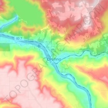
Naam: Topografische kaart Orofino, hoogte, reliëf.
Locatie: Orofino, Clearwater County, Idaho, 83544, United States (46.47097 -116.32122 46.49939 -116.19855)
Gemiddelde hoogte: 633 m
Minimale hoogte: 293 m
Maximale hoogte: 964 m
Due to the area’s relatively low elevation, the climate is ranked as among the hottest in the summer and the mildest in the winter throughout the entire state. The moderate winters are also influenced by the city’s northwestern location, which places it closer to the Pacific Ocean than many other parts of Idaho. Idaho’s all-time highest temperature of 118 °F or 47.8 °C was recorded at Orofino on July 28, 1934.
Andere topografische kaarten
Klik op een kaart om zijn topografie, zijn hoogte en zijn reliëf te bekijken.
Weippe
United States > Idaho > Clearwater County
Weippe, Clearwater County, Idaho, 83553, United States
Gemiddelde hoogte: 926 m
Ahsahka
United States > Idaho > Clearwater County
Ahsahka, Clearwater County, Idaho, 83520, United States
Gemiddelde hoogte: 422 m
Elk River
United States > Idaho > Clearwater County
Elk River, Clearwater County, Idaho, 83827, United States
Gemiddelde hoogte: 907 m
Pierce
United States > Idaho > Clearwater County
Pierce, Clearwater County, Idaho, 83546, United States
Gemiddelde hoogte: 1.004 m
Orofino
United States > Idaho > Clearwater County > Orofino > Orofino
Orofino, Clearwater County, Idaho, 83544, United States
Gemiddelde hoogte: 627 m