
Topografische kaart Lake Charles
Interactieve kaart
Klik op de kaart om de hoogte weer te geven.
Over deze kaart
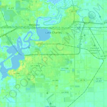
Naam: Topografische kaart Lake Charles, hoogte, reliëf.
Locatie: Lake Charles, Calcasieu Parish, Louisiana, United States (30.12450 -93.31686 30.27220 -93.12884)
Gemiddelde hoogte: 5 m
Minimale hoogte: -5 m
Maximale hoogte: 17 m
Lake Charles, located on a level plain about 30 miles (48 km) from the Gulf of Mexico, has an elevation of approximately 13 feet (4.0 m) above sea level, and is located on the banks of the Calcasieu River in southwestern Louisiana. It borders both Lake Charles and Prien Lake. Contraband Bayou, Henderson Bayou, and English Bayou flow through the city. Oak trees and pine trees dot the landscape; the lumber industry was once the main economic engine of the area. The Calcasieu Ship Channel, which allows large ocean-going vessels to sail up from the Gulf, also borders the city.
Andere topografische kaarten
Klik op een kaart om zijn topografie, zijn hoogte en zijn reliëf te bekijken.
Sulphur
United States > Louisiana > Calcasieu Parish
Sulphur, Calcasieu Parish, Louisiana, 70663, United States
Gemiddelde hoogte: 6 m
University Place
United States > Louisiana > Calcasieu Parish > Lake Charles
University Place, Lake Charles, Calcasieu Parish, Louisiana, 70609, United States
Gemiddelde hoogte: 7 m
Moss Bluff
United States > Louisiana > Calcasieu Parish
Moss Bluff, Calcasieu Parish, Louisiana, United States
Gemiddelde hoogte: 6 m