
Topografische kaart Boring
Interactieve kaart
Klik op de kaart om de hoogte weer te geven.
Boring
Boring's landscape is hilly, with its elevation ranging between 548 feet (167 m) and 755 feet (230 m). Several creeks run west through the community limits into the Clackamas River, including Doane Creek, North Fork Deep Creek, and Tickle Creek.
Over deze kaart
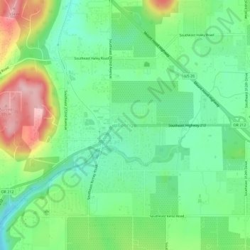
Naam: Topografische kaart Boring, hoogte, reliëf.
Locatie: Boring, Clackamas County, Oregon, 97009, United States (45.41266 -122.38951 45.45266 -122.34951)
Gemiddelde hoogte: 182 m
Minimale hoogte: 115 m
Maximale hoogte: 308 m
Andere topografische kaarten
Klik op een kaart om zijn topografie, zijn hoogte en zijn reliëf te bekijken.
Sandy
United States > Oregon > Clackamas County
According to the United States Census Bureau, the city has a total area of 3.14 square miles (8.13 km2), consisting almost entirely of land. Its elevation is 967 feet (295 m).
Gemiddelde hoogte: 247 m
Wilsonville
United States > Oregon > Clackamas County
Wilsonville is located on the southern edge of the Portland metropolitan area sitting at an elevation of 154 feet (47 m) above sea level. Primarily in the southwestern part of Clackamas County, the northern section is in Washington County. It is located on the north side of the Willamette River around where…
Gemiddelde hoogte: 60 m
Sandy
United States > Oregon > Clackamas County
According to the United States Census Bureau, the city has a total area of 3.14 square miles (8.13 km2), consisting almost entirely of land. Its elevation is 967 feet (295 m).
Gemiddelde hoogte: 247 m
Sandy
United States > Oregon > Clackamas County
According to the United States Census Bureau, the city has a total area of 3.14 square miles (8.13 km2), consisting almost entirely of land. Its elevation is 967 feet (295 m).
Gemiddelde hoogte: 247 m