
Topografische kaart Obonuco
Interactieve kaart
Klik op de kaart om de hoogte weer te geven.
Over deze kaart
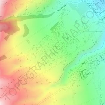
Naam: Topografische kaart Obonuco, hoogte, reliëf.
Locatie: Obonuco, Pasto, Centro, Nariño, RAP Pacífico, 520001, Colombia (1.17042 -77.32652 1.21042 -77.28652)
Gemiddelde hoogte: 2.852 m
Minimale hoogte: 2.575 m
Maximale hoogte: 3.270 m
Andere topografische kaarten
Klik op een kaart om zijn topografie, zijn hoogte en zijn reliëf te bekijken.
Comuna 4
Colombia > Nariño > Pasto > Perímetro Urbano Pasto
Comuna 4, Perímetro Urbano Pasto, Pasto, Centro, Nariño, RAP Pacífico, Colombia
Gemiddelde hoogte: 2.606 m
Laguna de la Cocha
Laguna de la Cocha, Pasto, Centro, Nariño, RAP Pacífico, Colombia
Gemiddelde hoogte: 2.966 m
El Encanto
El Encanto, Pasto, Centro, Nariño, RAP Pacífico, Colombia
Gemiddelde hoogte: 2.919 m
Isla de la Corota
Isla de la Corota, Pasto, Centro, Nariño, Colombia
Gemiddelde hoogte: 2.786 m
Perímetro Urbano Pasto
Perímetro Urbano Pasto, Pasto, Centro, Nariño, RAP Pacífico, Colombia
Gemiddelde hoogte: 2.676 m