
Topografische kaart Lake of the Prairies
Interactieve kaart
Klik op de kaart om de hoogte weer te geven.
Over deze kaart
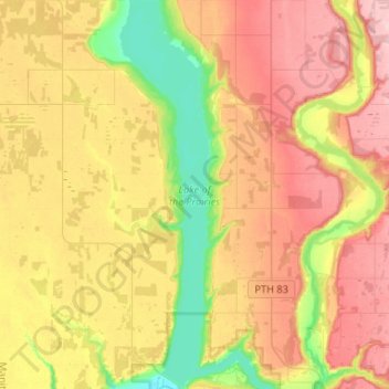
Naam: Topografische kaart Lake of the Prairies, hoogte, reliëf.
Gemiddelde hoogte: 502 m
Minimale hoogte: 415 m
Maximale hoogte: 587 m
Andere topografische kaarten
Klik op een kaart om zijn topografie, zijn hoogte en zijn reliëf te bekijken.
Angusville
Canada > Manitoba > Division No. 16 > Rural Municipality of Riding Mountain West > Angusville
Angusville, Rural Municipality of Riding Mountain West, Division No. 16, Manitoba, Canada
Gemiddelde hoogte: 579 m
Inglis
Canada > Manitoba > Division No. 16 > Rural Municipality of Riding Mountain West
Inglis, Rural Municipality of Riding Mountain West, Division No. 16, Manitoba, Canada
Gemiddelde hoogte: 571 m