
Topografische kaart Puncheston
Interactieve kaart
Klik op de kaart om de hoogte weer te geven.
Over deze kaart
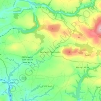
Naam: Topografische kaart Puncheston, hoogte, reliëf.
Locatie: Puncheston, Pembrokeshire, Wales, United Kingdom (51.90302 -4.96180 51.96009 -4.79285)
Gemiddelde hoogte: 165 m
Minimale hoogte: 28 m
Maximale hoogte: 465 m
A map of 1578 shows the parish as Castle Male, presumably a phonetic spelling of the Welsh name by the English mapmaker. Lewis's Topographical Dictionary of 1844 gives 326 inhabitants (the 1849 edition gives 255) for the parish, which includes the village and a number of outlying residences and farms. Lewis surmises that the original name was Castell Mael, deriving from an ancient encampment of which there are remains. A railway passed through the parish in the 19th and 20th centuries, with a halt at the village.