
Topografische kaart 龙兴街道
Interactieve kaart
Klik op de kaart om de hoogte weer te geven.
Over deze kaart
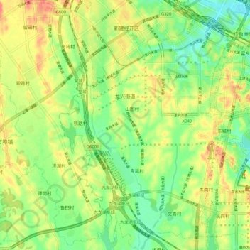
Naam: Topografische kaart 龙兴街道, hoogte, reliëf.
Locatie: 龙兴街道, Honggutan District, Nanchang, Jiangxi, China (28.55499 115.70279 28.64445 115.76770)
Gemiddelde hoogte: 44 m
Minimale hoogte: 18 m
Maximale hoogte: 74 m
Andere topografische kaarten
Klik op een kaart om zijn topografie, zijn hoogte en zijn reliëf te bekijken.
长埇许家村
China > Jiangxi > Honggutan District > 长桶村
长埇许家村, 红角洲街道, 长桶村, Honggutan District, Nanchang, Jiangxi, 330063, China
Gemiddelde hoogte: 30 m