
Topografische kaart Gryfice
Interactieve kaart
Klik op de kaart om de hoogte weer te geven.
Over deze kaart
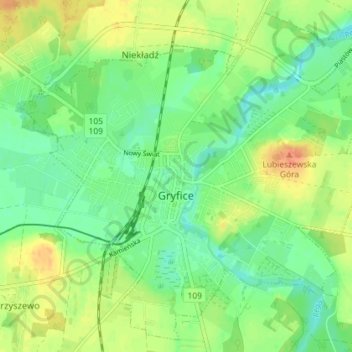
Naam: Topografische kaart Gryfice, hoogte, reliëf.
Gemiddelde hoogte: 24 m
Minimale hoogte: 8 m
Maximale hoogte: 46 m
Andere topografische kaarten
Klik op een kaart om zijn topografie, zijn hoogte en zijn reliëf te bekijken.
Wicimice
Poland > West Pomeranian Voivodeship > Gryfice County
Wicimice, gmina Płoty, Gryfice County, West Pomeranian Voivodeship, 72-311, Poland
Gemiddelde hoogte: 45 m
Trzebiatów
Poland > West Pomeranian Voivodeship > Gryfice County
Trzebiatów, gmina Trzebiatów, Gryfice County, West Pomeranian Voivodeship, Poland
Gemiddelde hoogte: 11 m