
Topografische kaart La Cage
Interactieve kaart
Klik op de kaart om de hoogte weer te geven.
Over deze kaart
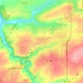
Naam: Topografische kaart La Cage, hoogte, reliëf.
Gemiddelde hoogte: 130 m
Minimale hoogte: 71 m
Maximale hoogte: 179 m
Andere topografische kaarten
Klik op een kaart om zijn topografie, zijn hoogte en zijn reliëf te bekijken.
La Goupillière
France > Normandie > Manche > Percy-en-Normandie > Percy
La Goupillière, Percy, Percy-en-Normandie, Saint-Lô, Manche, Normandie, France métropolitaine, 50410, France
Gemiddelde hoogte: 106 m
La Croix des Tondieres
France > Normandie > Manche > Percy-en-Normandie > Percy
La Croix des Tondieres, Percy, Percy-en-Normandie, Saint-Lô, Manche, Normandie, France métropolitaine, 50410, France
Gemiddelde hoogte: 121 m
Le Moulin de Haut
France > Normandie > Manche > Percy-en-Normandie > Percy
Le Moulin de Haut, Percy, Percy-en-Normandie, Saint-Lô, Manche, Normandie, France métropolitaine, 50410, France
Gemiddelde hoogte: 139 m