
Doe een donatie
Rust jezelf uit voor je volgende avontuur:
Als Amazon-partner verdient deze site een commissie op in aanmerking komende aankopen, zonder extra kosten voor jou.
Topografische kaart Coaldale
Klik op de kaart om de hoogte weer te geven.
Doe een donatie
Rust jezelf uit voor je volgende avontuur:
Als Amazon-partner verdient deze site een commissie op in aanmerking komende aankopen, zonder extra kosten voor jou.
Coaldale
Coaldale is located at 40°49′20″N 75°54′36″W / 40.82222°N 75.91000°W / 40.82222; -75.91000 (40.822234, -75.910115), which is (technically) one mile southwest of Lansford as both municipalities lie along the border of Carbon and Schuylkill Counties. It is also five miles northeast of Tamaqua, 27 miles northwest of Allentown, and nine miles south of Hazleton. It is located on the northwestern fringe of the Lehigh Valley and just two ridgelines away from the nearby Poconos, and drains to the Delaware River by way of Panther Creek, the Little Schuylkill River, and the Schuylkill River. Coaldale sits atop one of the richest coal seams in the eastern end of the southern Coal Region, which is still being exploited by a successor company of the LC&N (called the Old Company in the valley), the Lehigh Coal and Navigation Company (or the New Company). Coaldale's elevation is 1050 feet above sea level. According to the United States Census Bureau, the borough has a total area of 2.2 square miles (5.7 km2), all land.
Doe een donatie
Rust jezelf uit voor je volgende avontuur:
Als Amazon-partner verdient deze site een commissie op in aanmerking komende aankopen, zonder extra kosten voor jou.
Over deze kaart
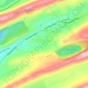
Naam: Topografische kaart Coaldale, hoogte, reliëf.
Locatie: Coaldale, Schuylkill County, Pennsylvania, United States (40.80509 -75.93646 40.83388 -75.89158)
Gemiddelde hoogte: 360 m
Minimale hoogte: 252 m
Maximale hoogte: 481 m
Doe een donatie
Rust jezelf uit voor je volgende avontuur:
Als Amazon-partner verdient deze site een commissie op in aanmerking komende aankopen, zonder extra kosten voor jou.
Andere topografische kaarten
Klik op een kaart om zijn topografie, zijn hoogte en zijn reliëf te bekijken.
Park Place
United States > Pennsylvania > Schuylkill County > Mahanoy Township
Gemiddelde hoogte: 515 m
Andreas
United States > Pennsylvania > Schuylkill County > West Penn Township
Gemiddelde hoogte: 250 m
Doe een donatie
Rust jezelf uit voor je volgende avontuur:
Als Amazon-partner verdient deze site een commissie op in aanmerking komende aankopen, zonder extra kosten voor jou.
Blue Mountain
United States > Pennsylvania > Schuylkill County > Washington Township
The ridge of Blue Mountain runs for 150 miles (240 km) through Pennsylvania, reaching an elevation of 2,270 feet (690 m) above sea level just north of the Pennsylvania Turnpike, near the borough of Newburg. Most of the ridgecrest, however, only reaches between 1,400 and 1,700 feet (430 and 520 m) in elevation.…
Gemiddelde hoogte: 226 m
Snyders
United States > Pennsylvania > Schuylkill County > West Penn Township
Gemiddelde hoogte: 242 m
Andreas
United States > Pennsylvania > Schuylkill County > West Penn Township
Gemiddelde hoogte: 250 m
Doe een donatie
Rust jezelf uit voor je volgende avontuur:
Als Amazon-partner verdient deze site een commissie op in aanmerking komende aankopen, zonder extra kosten voor jou.
Blue Mountain
United States > Pennsylvania > Schuylkill County > Washington Township
The ridge of Blue Mountain runs for 150 miles (240 km) through Pennsylvania, reaching an elevation of 2,270 feet (690 m) above sea level just north of the Pennsylvania Turnpike, near the borough of Newburg. Most of the ridgecrest, however, only reaches between 1,400 and 1,700 feet (430 and 520 m) in elevation.…
Gemiddelde hoogte: 226 m
Irving
United States > Pennsylvania > Schuylkill County > Pine Grove Township
Gemiddelde hoogte: 199 m
Doe een donatie
Rust jezelf uit voor je volgende avontuur:
Als Amazon-partner verdient deze site een commissie op in aanmerking komende aankopen, zonder extra kosten voor jou.
Blue Mountain
United States > Pennsylvania > Schuylkill County > Washington Township
The ridge of Blue Mountain runs for 150 miles (240 km) through Pennsylvania, reaching an elevation of 2,270 feet (690 m) above sea level just north of the Pennsylvania Turnpike, near the borough of Newburg. Most of the ridgecrest, however, only reaches between 1,400 and 1,700 feet (430 and 520 m) in elevation.…
Gemiddelde hoogte: 226 m
Nuremberg
United States > Pennsylvania > Schuylkill County > North Union Township
Gemiddelde hoogte: 377 m