
Topografische kaart Ponce Inlet
Interactieve kaart
Klik op de kaart om de hoogte weer te geven.
Over deze kaart
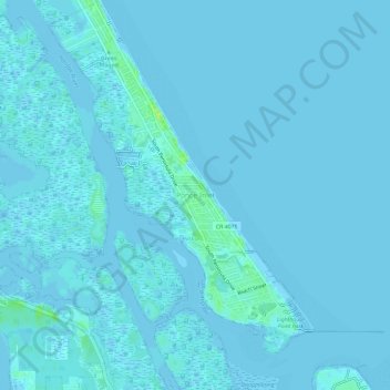
Naam: Topografische kaart Ponce Inlet, hoogte, reliëf.
Locatie: Ponce Inlet, Volusia County, Florida, United States (29.07046 -80.97531 29.12218 -80.91973)
Gemiddelde hoogte: 1 m
Minimale hoogte: -2 m
Maximale hoogte: 15 m
Andere topografische kaarten
Klik op een kaart om zijn topografie, zijn hoogte en zijn reliëf te bekijken.
DeLand
United States > Florida > Volusia County
DeLand, Volusia County, Florida, 32723, United States
Gemiddelde hoogte: 20 m
Deltona
United States > Florida > Volusia County > Deltona
Deltona, Volusia County, Florida, 32725, United States
Gemiddelde hoogte: 12 m
Port Orange
United States > Florida > Volusia County
Port Orange, Volusia County, Florida, United States
Gemiddelde hoogte: 6 m
Stone Island
United States > Florida > Volusia County
Stone Island, Volusia County, Florida, 32728, United States
Gemiddelde hoogte: 14 m
Daytona Beach
United States > Florida > Volusia County
Daytona Beach, Volusia County, Florida, United States
Gemiddelde hoogte: 5 m
Orange City
United States > Florida > Volusia County
Orange City, Volusia County, Florida, 32763, United States
Gemiddelde hoogte: 18 m