
Topografische kaart Blatten
Interactieve kaart
Klik op de kaart om de hoogte weer te geven.
Over deze kaart
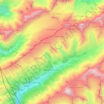
Naam: Topografische kaart Blatten, hoogte, reliëf.
Locatie: Blatten, Westlich Raron, Wallis, 3919, Switzerland (46.38912 7.76850 46.49825 7.96555)
Gemiddelde hoogte: 2.536 m
Minimale hoogte: 1.267 m
Maximale hoogte: 3.905 m
Blatten lies in the Lötschental valley south of the Bernese Alps. The municipality is located in the Westlich Raron district, and is the highest inhabited part of the Lötschental valley at an elevation of 1,540 m (5,050 ft). It consists of the village of Blatten and the hamlets of Eisten, Ried and Weissenried. At the head of the road up the valley, Fafleralp is the site of a well known hotel.
Andere topografische kaarten
Klik op een kaart om zijn topografie, zijn hoogte en zijn reliëf te bekijken.
Grosshorn
Switzerland > Wallis > Westlich Raron > Blatten
Grosshorn, Blatten, Westlich Raron, Wallis, 3919, Switzerland
Gemiddelde hoogte: 3.073 m
Lauchernalp
Switzerland > Wallis > Westlich Raron
Lauchernalp, Wiler (Lötschen), Westlich Raron, Wallis, 3918, Switzerland
Gemiddelde hoogte: 1.956 m
Raron
Switzerland > Wallis > Westlich Raron
Raron, Westlich Raron, Wallis, 3942, Switzerland
Gemiddelde hoogte: 1.712 m
Breithorn
Switzerland > Wallis > Westlich Raron > Blatten
Breithorn, Blatten, Westlich Raron, Wallis, 3919, Switzerland
Gemiddelde hoogte: 2.914 m