

Topografische kaart Penrose
Klik op de kaart om de hoogte weer te geven.
Over deze kaart
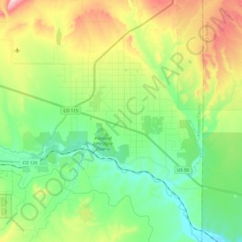
Naam: Topografische kaart Penrose, hoogte, reliëf.
Locatie: Penrose, Fremont County, Colorado, United States (38.33777 -105.06102 38.48550 -104.94073)
Gemiddelde hoogte: 1.629 m
Minimale hoogte: 1.500 m
Maximale hoogte: 1.883 m
Andere topografische kaarten
Klik op een kaart om zijn topografie, zijn hoogte en zijn reliëf te bekijken.
Cañon City
United States > Colorado > Fremont County
Cañon City is located in eastern Fremont County at 38°26′48″N 105°13′42″W / 38.44667°N 105.22833°W / 38.44667; -105.22833 (38.446800, -105.228305) at an altitude of 5,332 feet (1,625 m). It sits primarily on the north side of the Arkansas River, just east of where the river exits from…
Gemiddelde hoogte: 1.723 m




Cañon City
United States > Colorado > Fremont County
The city's nickname, "the Climate Capital of Colorado", derives from the combination of unique geography and 5,300-foot (1,600 m) elevation protecting the city from harsh weather conditions. The average daily high temperature in January is 14 °F (7.8 °C) warmer in Cañon City than in Grand Junction, even…
Gemiddelde hoogte: 1.723 m

Cañon City
United States > Colorado > Fremont County
The city's nickname, "the Climate Capital of Colorado", derives from the combination of unique geography and 5,300-foot (1,600 m) elevation protecting the city from harsh weather conditions. The average daily high temperature in January is 14 °F (7.8 °C) warmer in Cañon City than in Grand Junction, even…
Gemiddelde hoogte: 1.750 m


Cañon City
United States > Colorado > Fremont County
The city's nickname, "the Climate Capital of Colorado", derives from the combination of unique geography and 5,300-foot (1,600 m) elevation protecting the city from harsh weather conditions. The average daily high temperature in January is 14 °F (7.8 °C) warmer in Cañon City than in Grand Junction, even…
Gemiddelde hoogte: 1.750 m