
Topografische kaart Kellow Lake
Interactieve kaart
Klik op de kaart om de hoogte weer te geven.
Over deze kaart
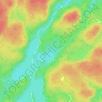
Naam: Topografische kaart Kellow Lake, hoogte, reliëf.
Gemiddelde hoogte: 294 m
Minimale hoogte: 264 m
Maximale hoogte: 321 m
Andere topografische kaarten
Klik op een kaart om zijn topografie, zijn hoogte en zijn reliëf te bekijken.
Camp 36 Lake
Canada > Ontario > Thunder Bay District > Unorganized Thunder Bay District
Camp 36 Lake, Unorganized Thunder Bay District, Thunder Bay District, Northwestern Ontario, Ontario, Canada
Gemiddelde hoogte: 269 m