
Topografische kaart Kannur
Interactieve kaart
Klik op de kaart om de hoogte weer te geven.
Kannur
Kannur has an elevation of 1.02 metres or 3.3 feet along the coast of the Laccadive Sea, with a sandy coastal area. The city has an 8 kilometres (5.0 mi)-long seashore and a 3 kilometres (1.9 mi)-long beach at Payyambalam. Kannur is located north of Kozhikode, south of Kasargod and Mangalore, west of the Western Ghat regions of Kodagu and Wayanad, and east of the Laccadive Sea. Mappila Bay harbour at Ayikkara. On one side, there is St. Angelo Fort (built in 1505) and on the other side is Arakkal palace. Muzhappilangad Beach, the longest Drive-in Beach in Asia, is located in Kannur. Vayalapra Lake is near Madayi.
Over deze kaart
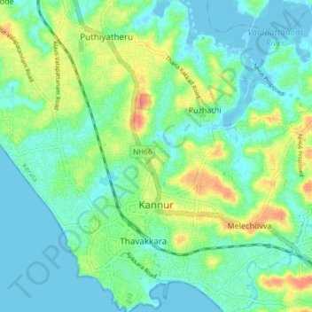
Naam: Topografische kaart Kannur, hoogte, reliëf.
Locatie: Kannur, Kerala, India (11.85163 75.35289 11.92379 75.40426)
Gemiddelde hoogte: 14 m
Minimale hoogte: -5 m
Maximale hoogte: 45 m
Andere topografische kaarten
Klik op een kaart om zijn topografie, zijn hoogte en zijn reliëf te bekijken.
Kannur
India > Kerala > Kannur > Kannur
Kannur has an elevation of 1.02 metres or 3.3 feet along the coast of the Laccadive Sea, with a sandy coastal area. The city has an 8 kilometres (5.0 mi)-long seashore and a 3 kilometres (1.9 mi)-long beach at Payyambalam. Kannur is located north of Kozhikode, south of Kasargod and Mangalore, west of the…
Gemiddelde hoogte: 13 m