
Topografische kaart Forchheim
Interactieve kaart
Klik op de kaart om de hoogte weer te geven.
Over deze kaart
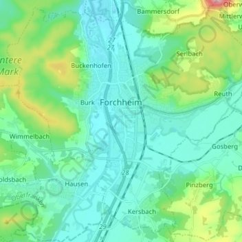
Naam: Topografische kaart Forchheim, hoogte, reliëf.
Locatie: Forchheim, Landkreis Forchheim, Bavaria, 91301, Germany (49.67385 10.99958 49.75090 11.12663)
Gemiddelde hoogte: 299 m
Minimale hoogte: 250 m
Maximale hoogte: 493 m
Forchheim (German pronunciation: [ˈfɔʁçhaɪ̯m] (listen)) is a town in Upper Franconia (German: Oberfranken) in northern Bavaria, and also the seat of the administrative district of Forchheim. Forchheim is a former royal city, and is sometimes called the Gateway to the Franconian Switzerland, referring to the region of outstanding natural beauty to the north east of the town. Nowadays Forchheim is most famous for its ten day long beer and music festival (Annafest) which takes place in late July in an idyllic wooded hillside, home to 24 beer gardens, on the outskirts of the town. Forchheim's population, as of December 2013, was 30,705, and its land area is 44.95 square kilometres (17.36 square miles). Its position is 49° 44' N, 11° 04' E and its elevation is 265 metres (869 feet) above sea level.
Andere topografische kaarten
Klik op een kaart om zijn topografie, zijn hoogte en zijn reliëf te bekijken.
Trainmeusel
Germany > Bavaria > Landkreis Forchheim > Wiesenttal
Trainmeusel, Wiesenttal, Landkreis Forchheim, Bavaria, 91346, Germany
Gemiddelde hoogte: 433 m
Ebermannstadt
Germany > Bavaria > Landkreis Forchheim > Ebermannstadt > Ebermannstadt
Ebermannstadt, Ebermannstadt (VGem), Landkreis Forchheim, Bavaria, 91320, Germany
Gemiddelde hoogte: 408 m
Leutenbach
Germany > Bavaria > Landkreis Forchheim
Leutenbach, Kirchehrenbach (VGem), Landkreis Forchheim, Bavaria, 91359, Germany
Gemiddelde hoogte: 410 m