
Topografische kaart Loch Lomond and The Trossachs National Park
Interactieve kaart
Klik op de kaart om de hoogte weer te geven.
Loch Lomond and The Trossachs National Park
The park straddles the Highland Boundary Fault, which divides it into two distinct regions - lowland and highland - that differ in underlying geology, soil types and topography. The change in rock type can most clearly be seen at Loch Lomond itself, as the fault runs across the islands of Inchmurrin, Creinch, Torrinch and Inchcailloch and over the ridge of Conic Hill. To the south lie green fields and cultivated land; to the north, mountains.
Over deze kaart
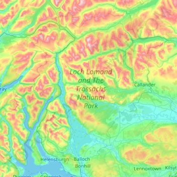
Naam: Topografische kaart Loch Lomond and The Trossachs National Park, hoogte, reliëf.
Gemiddelde hoogte: 291 m
Minimale hoogte: -1 m
Maximale hoogte: 1.137 m
Andere topografische kaarten
Klik op een kaart om zijn topografie, zijn hoogte en zijn reliëf te bekijken.