
Topografische kaart Ferndale
Interactieve kaart
Klik op de kaart om de hoogte weer te geven.
Over deze kaart
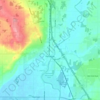
Naam: Topografische kaart Ferndale, hoogte, reliëf.
Locatie: Ferndale, Whatcom County, Washington, United States (48.81709 -122.63328 48.88463 -122.55058)
Gemiddelde hoogte: 29 m
Minimale hoogte: -2 m
Maximale hoogte: 120 m
Andere topografische kaarten
Klik op een kaart om zijn topografie, zijn hoogte en zijn reliëf te bekijken.
Point Roberts
United States > Washington > Whatcom County > Point Roberts
Point Roberts, Whatcom County, Washington, 98281, United States
Gemiddelde hoogte: 9 m
Sudden Valley
United States > Washington > Whatcom County
Sudden Valley, Whatcom County, Washington, United States
Gemiddelde hoogte: 239 m
Birch Bay
United States > Washington > Whatcom County
Birch Bay, Whatcom County, Washington, United States
Gemiddelde hoogte: 21 m
Maple Falls
United States > Washington > Whatcom County
Maple Falls, Whatcom County, Washington, United States
Gemiddelde hoogte: 442 m
Lynden
United States > Washington > Whatcom County
Lynden, Whatcom County, Washington, United States
Gemiddelde hoogte: 26 m
Sumas
United States > Washington > Whatcom County
Sumas, Whatcom County, Washington, 98295, United States
Gemiddelde hoogte: 15 m
Mount Baker
United States > Washington > Whatcom County
Mount Baker, Whatcom County, Washington, United States
Gemiddelde hoogte: 2.699 m
Bellingham
United States > Washington > Whatcom County
Bellingham, Whatcom County, Washington, United States
Gemiddelde hoogte: 89 m
Blaine
United States > Washington > Whatcom County
Blaine, Whatcom County, Washington, 98231, United States
Gemiddelde hoogte: 23 m
Newhalem
United States > Washington > Whatcom County
Newhalem, Whatcom County, Washington, United States
Gemiddelde hoogte: 492 m