
Topografische kaart Marine Corps Base Hawaii Kaneohe
Interactieve kaart
Klik op de kaart om de hoogte weer te geven.
Over deze kaart
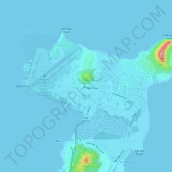
Naam: Topografische kaart Marine Corps Base Hawaii Kaneohe, hoogte, reliëf.
Gemiddelde hoogte: 7 m
Minimale hoogte: -5 m
Maximale hoogte: 198 m
Andere topografische kaarten
Klik op een kaart om zijn topografie, zijn hoogte en zijn reliëf te bekijken.
Kapunahala
United States > Hawaii > Honolulu County > Kaneohe
Kapunahala, Kaneohe, Honolulu County, Hawaii, 96744, United States
Gemiddelde hoogte: 91 m
Kokokahi
United States > Hawaii > Honolulu County > Kaneohe
Kokokahi, Kaneohe, Honolulu County, Hawaii, 96744, United States
Gemiddelde hoogte: 27 m
Ho'omaluhia Botanical Garden
United States > Hawaii > Honolulu County > Kaneohe > Keapuka
Ho'omaluhia Botanical Garden, Keapuka, Kaneohe, Honolulu County, Hawaii, 96744, United States
Gemiddelde hoogte: 155 m