
Topografische kaart Cambria
Interactieve kaart
Klik op de kaart om de hoogte weer te geven.
Over deze kaart
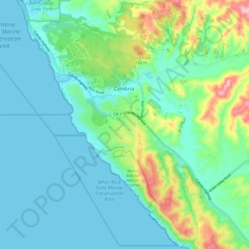
Naam: Topografische kaart Cambria, hoogte, reliëf.
Gemiddelde hoogte: 52 m
Minimale hoogte: 0 m
Maximale hoogte: 249 m
Originally an American settlement called Slab Town, the town later known as Cambria was centered at the Leffingwell cove of today's northern Moonstone Beach, which beach also featured a wharf. Because lumber production, ranching activities and mercury mining increased in the area, the village adopted the more dignified name of Cambria. Locals seem to agree that the name was contributed by a local surveyor from Cambria County, Pennsylvania, because the local topography and flora reminded him of that place. However this differs from Onomastic data published in several other sources. A 1960 study of California place names, often contemporarily quoted elsewhere states "A Welshman named Llewellyn dubbed his shop 'The Cambria Carpenter Shop,' and in 1869, the good folks adopted it as the official name." Forty-three years prior to that, the History of San Luis Obispo County and environs contains a similar account: