
Topografische kaart Kilcullen
Interactieve kaart
Klik op de kaart om de hoogte weer te geven.
Over deze kaart
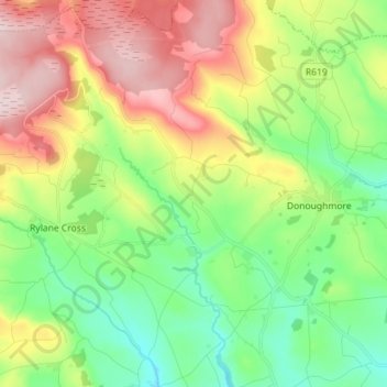
Naam: Topografische kaart Kilcullen, hoogte, reliëf.
Locatie: Kilcullen, Blarney - Macroom, County Cork, Munster, Ireland (51.94917 -8.86747 52.03401 -8.72586)
Gemiddelde hoogte: 216 m
Minimale hoogte: 105 m
Maximale hoogte: 390 m
Andere topografische kaarten
Klik op een kaart om zijn topografie, zijn hoogte en zijn reliëf te bekijken.
Newcestown
Newcestown, Murragh, Blarney - Macroom, County Cork, Munster, Ireland
Gemiddelde hoogte: 156 m
Aherla
Aherla, Kilbonane, Blarney - Macroom, County Cork, Munster, Ireland
Gemiddelde hoogte: 84 m
Blarney
Blarney, Blarney - Macroom, Cork City 2019, County Cork, Munster, T23 VY22, Ireland
Gemiddelde hoogte: 97 m
Liscarrigane
Liscarrigane, Ullanes, Blarney - Macroom, County Cork, Munster, Ireland
Gemiddelde hoogte: 240 m
Inishcarra
Inishcarra, Carrigrohane Beg, Blarney - Macroom, County Cork, Munster, P31 HY26, Ireland
Gemiddelde hoogte: 72 m
Clondrohid
Clondrohid, Blarney - Macroom, County Cork, Munster, Ireland
Gemiddelde hoogte: 151 m
Cloghduff
Cloghduff, Moviddy, Blarney - Macroom, County Cork, Munster, Ireland
Gemiddelde hoogte: 101 m
Seefin
Seefin, Blarney - Macroom, County Cork, Munster, Ireland
Gemiddelde hoogte: 384 m
Killumney
Killumney, Ballygroman, Blarney - Macroom, County Cork, Munster, Ireland
Gemiddelde hoogte: 81 m
Mullaghanish
Mullaghanish, Blarney - Macroom, County Cork, Munster, Ireland
Gemiddelde hoogte: 474 m
Clearagh
Clearagh, Greenville, Blarney - Macroom, County Cork, Munster, Ireland
Gemiddelde hoogte: 190 m
Cloghroe
Ireland > Blarney - Macroom > Cloghroe
Cloghroe, Blarney - Macroom, County Cork, Munster, T23 YX51, Ireland
Gemiddelde hoogte: 77 m
Musheramore
Musheramore, Blarney - Macroom, County Cork, Munster, Ireland
Gemiddelde hoogte: 429 m