
Topografische kaart Volga River
Interactieve kaart
Klik op de kaart om de hoogte weer te geven.
Over deze kaart
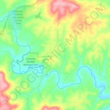
Naam: Topografische kaart Volga River, hoogte, reliëf.
Gemiddelde hoogte: 268 m
Minimale hoogte: 211 m
Maximale hoogte: 358 m
Andere topografische kaarten
Klik op een kaart om zijn topografie, zijn hoogte en zijn reliëf te bekijken.
Glenwood
United States of America > Iowa > Glenwood
Glenwood, Mills County, Iowa, 51534, United States of America
Gemiddelde hoogte: 327 m
Key West
United States of America > Iowa > Key West
Key West, Dubuque County, Iowa, 52003, United States of America
Gemiddelde hoogte: 233 m
Osborne
United States of America > Iowa > Osborne
Osborne, Clayton County, Iowa, United States of America
Gemiddelde hoogte: 269 m
Montezuma
United States of America > Iowa > Montezuma
Montezuma, Poweshiek County, Iowa, 50171, United States of America
Gemiddelde hoogte: 284 m
Inwood
United States of America > Iowa > Inwood
Inwood, Lyon County, Iowa, United States of America
Gemiddelde hoogte: 444 m
Durant
United States of America > Iowa > Durant
Durant, Cedar County, Iowa, 552747, United States of America
Gemiddelde hoogte: 215 m
Griswold
United States of America > Iowa > Griswold
Griswold, Cass County, Iowa, United States of America
Gemiddelde hoogte: 336 m
Browns Lake/IPS Wildlife Management Area
United States of America > Iowa
Browns Lake/IPS Wildlife Management Area, Woodbury County, Iowa, 51052, United States of America
Gemiddelde hoogte: 328 m
Milton
United States of America > Iowa > Milton
Milton, Iowa, United States of America
Gemiddelde hoogte: 239 m
Hartwick
United States of America > Iowa > Hartwick > Hartwick
Hartwick, Poweshiek County, Iowa, 52232, United States of America
Gemiddelde hoogte: 278 m
Burr Oak
United States of America > Iowa > Burr Oak > Burr Oak
Burr Oak, Winneshiek County, Iowa, United States of America
Gemiddelde hoogte: 384 m