
Topografische kaart Gurteen Registrars District
Interactieve kaart
Klik op de kaart om de hoogte weer te geven.
Over deze kaart
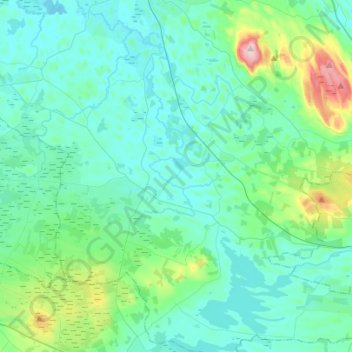
Naam: Topografische kaart Gurteen Registrars District, hoogte, reliëf.
Locatie: Gurteen Registrars District, County Sligo, Connacht, Ireland (53.92099 -8.59425 54.08433 -8.39787)
Gemiddelde hoogte: 99 m
Minimale hoogte: 52 m
Maximale hoogte: 352 m
Andere topografische kaarten
Klik op een kaart om zijn topografie, zijn hoogte en zijn reliëf te bekijken.
Sligo
Sligo, Sligo Municipal Borough District, County Sligo, Connacht, Ireland
Gemiddelde hoogte: 21 m
Rathcormack
Rathcormack, Drumcliff South, Drumcliff West ED, Sligo Municipal Borough District, County Sligo, Connacht, F91 PY24, Ireland
Gemiddelde hoogte: 27 m
Dromore West
Dromore West, Ballymote-Tubbercurry Municipal District, County Sligo, Connacht, Ireland
Gemiddelde hoogte: 51 m
Dawros
Dawros, Banada ED, Ballymote-Tubbercurry Municipal District, County Sligo, Connacht, Ireland
Gemiddelde hoogte: 52 m
Rosses Point
Rosses Point, County Sligo, Connacht, Ireland
Gemiddelde hoogte: 8 m
Kesh
Kesh, Ballymote-Tubbercurry Municipal District, County Sligo, Connacht, Ireland
Gemiddelde hoogte: 122 m
Oyster Island
Oyster Island, Knockaree ED, Sligo Municipal Borough District, County Sligo, Connacht, Ireland
Gemiddelde hoogte: 5 m
Rosses Point Beach
Rosses Point Beach, Rosses Lower, Drumcliff West ED, Sligo Municipal Borough District, County Sligo, Connacht, Ireland
Gemiddelde hoogte: 5 m
Coney Island
Coney Island, Knockaree ED, Sligo Municipal Borough District, County Sligo, Connacht, Ireland
Gemiddelde hoogte: 1 m
Tobercurry
Tobercurry, Tobercurry ED, Ballymote-Tubbercurry Municipal District, County Sligo, Connacht, Ireland
Gemiddelde hoogte: 91 m
Coolaney
Coolaney, Coolaney ED, Ballymote-Tubbercurry Municipal District, County Sligo, Connacht, F56 YX60, Ireland
Gemiddelde hoogte: 77 m
Beltra
Beltra, Tanrego East or Carrowmore, Dromard East ED, Ballymote-Tubbercurry Municipal District, County Sligo, Connacht, F56 YX60, Ireland
Gemiddelde hoogte: 19 m
Loughil ED
Loughil ED, Ballymote-Tubbercurry Municipal District, County Sligo, Connacht, Ireland
Gemiddelde hoogte: 272 m
Dooney Rock
Dooney Rock, Ballintogher West ED, Sligo Municipal Borough District, County Sligo, Connacht, F91 DH2K, Ireland
Gemiddelde hoogte: 53 m
Finisklin
Finisklin, Drumrat ED, Ballymote-Tubbercurry Municipal District, County Sligo, Connacht, Ireland
Gemiddelde hoogte: 69 m
Lavally
Lavally, Ballymote ED, Ballymote-Tubbercurry Municipal District, County Sligo, Connacht, Ireland
Gemiddelde hoogte: 94 m
Rosses Point
Rosses Point, Rosses Lower, Drumcliff West ED, Sligo Municipal Borough District, County Sligo, Connacht, F91 WP6N, Ireland
Gemiddelde hoogte: 4 m
Strandhill
Ireland > County Sligo > Strandhill
Strandhill, Sligo Municipal Borough District, County Sligo, Connacht, F91 WP6N, Ireland
Gemiddelde hoogte: 38 m
Moneygold
Moneygold, Cliffony South ED, Sligo Municipal Borough District, County Sligo, Connacht, Ireland
Gemiddelde hoogte: 17 m
Oldgrange
Oldgrange, Easky West ED, Ballymote-Tubbercurry Municipal District, County Sligo, Connacht, Ireland
Gemiddelde hoogte: 15 m
Carrowcoller
Carrowcoller, Kilglass ED, Ballymote-Tubbercurry Municipal District, County Sligo, Connacht, Ireland
Gemiddelde hoogte: 60 m
Ballyconnell
Ballyconnell, Lissadill West Electoral Division, Sligo Municipal Borough District, County Sligo, Connacht, Ireland
Gemiddelde hoogte: 8 m
Carrowbunnaun
Carrowbunnaun, Knockaree ED, Sligo Municipal Borough District, County Sligo, Connacht, Ireland
Gemiddelde hoogte: 36 m
Doonmadden
Doonmadden, Templeboy North ED, Ballymote-Tubbercurry Municipal District, County Sligo, Connacht, Ireland
Gemiddelde hoogte: 21 m
Kilrusheighter
Kilrusheighter, Templeboy North ED, Ballymote-Tubbercurry Municipal District, County Sligo, Connacht, Ireland
Gemiddelde hoogte: 12 m
Creevagh
Creevagh, Kilmactranny ED, Ballymote-Tubbercurry Municipal District, County Sligo, Connacht, Ireland
Gemiddelde hoogte: 69 m
Carrownrush
Carrownrush, Dromore ED, Ballymote-Tubbercurry Municipal District, County Sligo, Connacht, Ireland
Gemiddelde hoogte: 24 m
Muckduff
Muckduff, Castleconor West Electoral Division, Ballymote-Tubbercurry Municipal District, County Sligo, Connacht, Ireland
Gemiddelde hoogte: 23 m
Carrowgilhooly
Carrowgilhooly, Toberpatrick West ED, Ballymote-Tubbercurry Municipal District, County Sligo, Connacht, Ireland
Gemiddelde hoogte: 30 m
Drumcliff Round Tower
Drumcliff Round Tower, N15, Drumcliff South, Drumcliff West ED, Sligo Municipal Borough District, County Sligo, Connacht, F91 DK74, Ireland
Gemiddelde hoogte: 10 m
Carrowhubbuck North
Carrowhubbuck North, Kilglass ED, Ballymote-Tubbercurry Municipal District, County Sligo, Connacht, Ireland
Gemiddelde hoogte: 20 m
Aughris
Aughris, Aughris ED, Ballymote-Tubbercurry Municipal District, County Sligo, Connacht, Ireland
Gemiddelde hoogte: 7 m
Cuiltylough
Cuiltylough, Riverstown ED, Ballymote-Tubbercurry Municipal District, County Sligo, Connacht, Ireland
Gemiddelde hoogte: 58 m
Drumcliffe Parish
Drumcliffe Parish, County Sligo, Connacht, Ireland
Gemiddelde hoogte: 99 m
Markree Demesne
Markree Demesne, Collooney ED, Sligo Municipal Borough District, County Sligo, Connacht, Ireland
Gemiddelde hoogte: 37 m
Ballymote-Tubbercurry Municipal District
Ballymote-Tubbercurry Municipal District, County Sligo, Connacht, Ireland
Gemiddelde hoogte: 100 m
Geevagh
Geevagh, Ballynashee ED, Ballymote-Tubbercurry Municipal District, County Sligo, Connacht, Ireland
Gemiddelde hoogte: 92 m
Sligo Municipal Borough District
Sligo Municipal Borough District, County Sligo, Connacht, Ireland
Gemiddelde hoogte: 87 m
Ballymote-Tubbercurry Municipal District
Ballymote-Tubbercurry Municipal District, County Sligo, Connacht, Ireland, Cloonacool
Gemiddelde hoogte: 302 m