
Topografische kaart Mai Châu District
Interactieve kaart
Klik op de kaart om de hoogte weer te geven.
Over deze kaart
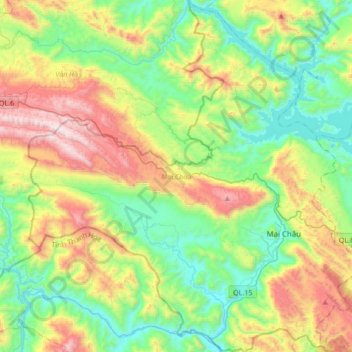
Naam: Topografische kaart Mai Châu District, hoogte, reliëf.
Locatie: Mai Châu District, Hoà Bình province, Vietnam (20.55722 104.83648 20.87561 105.15879)
Gemiddelde hoogte: 549 m
Minimale hoogte: 74 m
Maximale hoogte: 1.504 m
Mai Châu is a mountainous region located in Hòa Bình Province, approximately 135 km from Hanoi and 65 km from Hòa Bình. The east of Mai Châu borders Đà Bắc and Tân Lạc districts, the west and the south border Quan Hóa district of Thanh Hóa province, and the north borders Vân Hồ district of Sơn La province. Mai Châu's terrain is quite complex, divided by slits, streams and high mountains. According to the topographic characteristics, Mai Châu can be divided into two distinct areas: the low region (relatively flat terrain with fertile soil) and the high region (with many high and rugged mountain ranges).
Andere topografische kaarten
Klik op een kaart om zijn topografie, zijn hoogte en zijn reliëf te bekijken.
Yên Thủy District
Yên Thủy District, Hoà Bình province, Vietnam
Gemiddelde hoogte: 125 m
Bản Lác
Vietnam > Hoa Binh province > Mai Châu District > Chiềng Châu
Bản Lác, Chiềng Châu, Mai Châu District, Hoà Bình province, Vietnam
Gemiddelde hoogte: 279 m
Tân Lạc District
Tân Lạc District, Hoà Bình province, Vietnam
Gemiddelde hoogte: 416 m