
Topografische kaart Coldwater
Interactieve kaart
Klik op de kaart om de hoogte weer te geven.
Over deze kaart
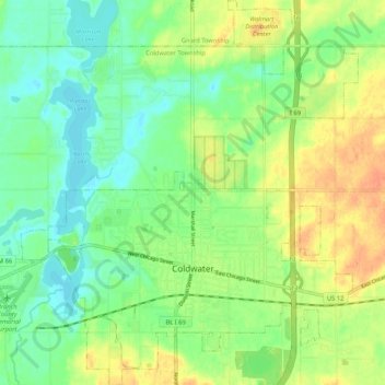
Naam: Topografische kaart Coldwater, hoogte, reliëf.
Locatie: Coldwater, Branch County, Michigan, United States of America (41.91658 -85.04757 41.99473 -84.95543)
Gemiddelde hoogte: 296 m
Minimale hoogte: 279 m
Maximale hoogte: 318 m
Coldwater is at 41°56′25″N 85°00′02″W / 41.94028°N 85.00056°W / 41.94028; -85.00056. The ZIP code is 49036 and the FIPS place code is 17020. The elevation is 969 feet (295 m) above sea level. The City of Coldwater is entirely surrounded by the Township of Coldwater.