
Topografische kaart Hume Lake
Interactieve kaart
Klik op de kaart om de hoogte weer te geven.
Hume Lake
The surface elevation of the lake is 1,586.34 m (5,204.5 ft). It is accessible from California Route 180, via Forest Service road 30, and is about 51 mi (82 km) east of Fresno, not far from the west entrance to Kings Canyon National Park.
Over deze kaart
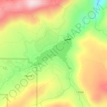
Naam: Topografische kaart Hume Lake, hoogte, reliëf.
Locatie: Hume Lake, Hume, Fresno County, California, United States (36.78691 -118.91295 36.79437 -118.90006)
Gemiddelde hoogte: 1.661 m
Minimale hoogte: 1.427 m
Maximale hoogte: 1.887 m