
Topografische kaart Mathon
Interactieve kaart
Klik op de kaart om de hoogte weer te geven.
Over deze kaart
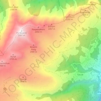
Naam: Topografische kaart Mathon, hoogte, reliëf.
Locatie: Mathon, Muntogna da Schons, Viamala, Grisons, 7433, Switzerland (46.62476 9.33704 46.65706 9.42337)
Gemiddelde hoogte: 1.994 m
Minimale hoogte: 961 m
Maximale hoogte: 2.987 m
Before 2017, the former municipality was located in the Schams sub-district, of the Hinterrhein district, after 2017 it was part of the Viamala Region.[6] The village is a haufendorf (an irregular, unplanned and quite closely packed village, built around a central square) at an elevation of 1,521 m (4,990 ft) in the center of the upper Schamserberg region.