
Topografische kaart Petit-Serré
Interactieve kaart
Klik op de kaart om de hoogte weer te geven.
Over deze kaart
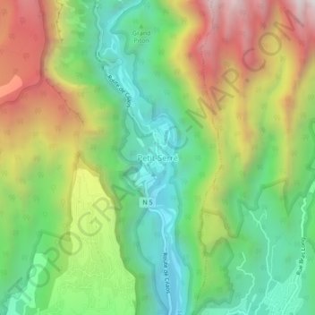
Naam: Topografische kaart Petit-Serré, hoogte, reliëf.
Gemiddelde hoogte: 790 m
Minimale hoogte: 240 m
Maximale hoogte: 1.615 m
Andere topografische kaarten
Klik op een kaart om zijn topografie, zijn hoogte en zijn reliëf te bekijken.
Les Makes
France > La Réunion > Saint-Louis
Les Makes, Saint-Louis, Saint-Pierre, La Réunion, France
Gemiddelde hoogte: 987 m
Plateau Goyaves
France > La Réunion > Saint-Louis
Plateau Goyaves, Saint-Louis, Saint-Pierre, La Réunion, 97450, France
Gemiddelde hoogte: 101 m
Roche Maigre
France > La Réunion > Saint-Louis > Plateau Goyaves
Roche Maigre, Plateau Goyaves, Saint-Louis, Saint-Pierre, La Réunion, 97450, France
Gemiddelde hoogte: 148 m
Rivière Saint-Étienne
France > La Réunion > Saint-Louis
Rivière Saint-Étienne, Saint-Louis, Saint-Pierre, La Réunion, 97450, France
Gemiddelde hoogte: 12 m
Ravine du Maniron
France > La Réunion > Saint-Louis
Ravine du Maniron, Saint-Louis, Saint-Pierre, La Réunion, 97450, France
Gemiddelde hoogte: 6 m
Bellevue
France > La Réunion > Saint-Louis > Bellevue
Bellevue, Saint-Louis, Saint-Pierre, La Réunion, 97450, France
Gemiddelde hoogte: 303 m