
Topografische kaart Mount Barker
Interactieve kaart
Klik op de kaart om de hoogte weer te geven.
Over deze kaart
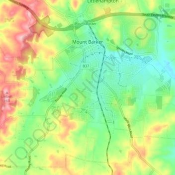
Naam: Topografische kaart Mount Barker, hoogte, reliëf.
Gemiddelde hoogte: 368 m
Minimale hoogte: 302 m
Maximale hoogte: 467 m
Mount Barker is located on the plains surrounding the Mount Barker Summit, about 2 km west of the mountain itself, at 35°04′S 138°51′E / 35.067°S 138.850°E / -35.067; 138.850. Mount Barker is south east of Mount Lofty and Adelaide. It is to the north of The Coorong, and the west of Murray Bridge. Mount Barker is at an elevation of 360 m.
Andere topografische kaarten
Klik op een kaart om zijn topografie, zijn hoogte en zijn reliëf te bekijken.
Wistow
Australia > South Australia > Mount Barker District Council
Wistow, Mount Barker District Council, South Australia, 5251, Australia
Gemiddelde hoogte: 334 m
Bull Creek
Australia > South Australia > Mount Barker District Council
Bull Creek, Mount Barker District Council, South Australia, 5157, Australia
Gemiddelde hoogte: 336 m
Callington
Australia > South Australia > Mount Barker District Council
Callington, Mount Barker District Council, South Australia, 5254, Australia
Gemiddelde hoogte: 151 m
Prospect Hill
Australia > South Australia > Mount Barker District Council
Prospect Hill, Mount Barker District Council, South Australia, 5201, Australia
Gemiddelde hoogte: 349 m
Nairne
Australia > South Australia > Mount Barker District Council
Nairne, Mount Barker District Council, South Australia, 5252, Australia
Gemiddelde hoogte: 383 m
Hahndorf
Australia > South Australia > Mount Barker District Council
Hahndorf, Mount Barker District Council, South Australia, 5245, Australia
Gemiddelde hoogte: 371 m
Kanmantoo
Australia > South Australia > Mount Barker District Council
Kanmantoo, Mount Barker District Council, South Australia, 5252, Australia
Gemiddelde hoogte: 198 m