
Topografische kaart Nitinat Lake
Interactieve kaart
Klik op de kaart om de hoogte weer te geven.
Over deze kaart
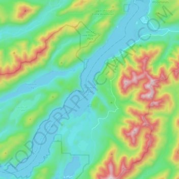
Naam: Topografische kaart Nitinat Lake, hoogte, reliëf.
Gemiddelde hoogte: 268 m
Minimale hoogte: -7 m
Maximale hoogte: 1.026 m
Andere topografische kaarten
Klik op een kaart om zijn topografie, zijn hoogte en zijn reliëf te bekijken.
Honeymoon Bay
Canada > British Columbia > Cowichan Valley Regional District > Area F (Cowichan Lake South / Skutz Falls)
Honeymoon Bay, Area F (Cowichan Lake South / Skutz Falls), Cowichan Valley Regional District, British Columbia, V0R 1Y0, Canada
Gemiddelde hoogte: 230 m