
Topografische kaart Kea
Interactieve kaart
Klik op de kaart om de hoogte weer te geven.
Over deze kaart
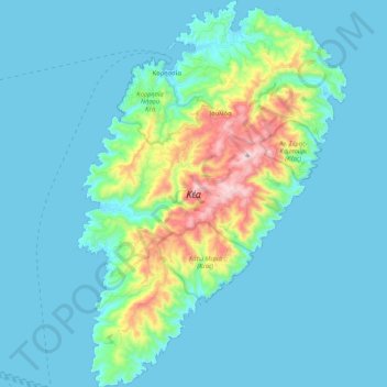
Naam: Topografische kaart Kea, hoogte, reliëf.
Gemiddelde hoogte: 81 m
Minimale hoogte: 0 m
Maximale hoogte: 565 m
Its capital, Ioulis, is inland at a high altitude (like most ancient Cycladic settlements, for fear of pirates) and is considered quite picturesque. Other major villages of Kea are the port of Korissia and the fishing village of Vourkari. After suffering depopulation for many decades, Kea has been recently rediscovered by Athenians as a convenient destination for weekend and yachting trips. The population in 2019 was 2,568.
Andere topografische kaarten
Klik op een kaart om zijn topografie, zijn hoogte en zijn reliëf te bekijken.
Βουρκάρι
Greece > Aegean > Kea-Kythnos Regional Unit > Korissia
Βουρκάρι, Korissia, Kea Municipality, Kea-Kythnos Regional Unit, South Aegean, Aegean, 840 02, Greece
Gemiddelde hoogte: 63 m