
Topografische kaart Crabtree Falls
Interactieve kaart
Klik op de kaart om de hoogte weer te geven.
Over deze kaart
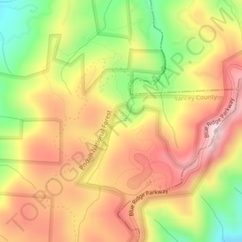
Naam: Topografische kaart Crabtree Falls, hoogte, reliëf.
Locatie: Crabtree Falls, Yancey County, North Carolina, United States (35.81971 -82.14964 35.81981 -82.14954)
Gemiddelde hoogte: 1.056 m
Minimale hoogte: 846 m
Maximale hoogte: 1.225 m
The Celo USGS topographic quadrangle map labels this falls "Upper Falls", and shows another waterfall some distance away and on another creek being called Crabtree Falls. Originally, the falls was known as Murphy's Falls and a small community was located nearby, including a church and blacksmith shop. When the Blue Ridge Parkway was constructed in the 1930s, the falls was renamed Crabtree Falls by the National Park Service.
Andere topografische kaarten
Klik op een kaart om zijn topografie, zijn hoogte en zijn reliëf te bekijken.
Appalachian Mountains
United States > North Carolina > Yancey County
Appalachian Mountains, Yancey County, North Carolina, United States
Gemiddelde hoogte: 1.463 m
South Toe River
United States > North Carolina > Yancey County > Hamrick
South Toe River, Hamrick, Yancey County, North Carolina, 38714, United States
Gemiddelde hoogte: 920 m
Bowlens Creek
United States > North Carolina > Yancey County
Bowlens Creek, Yancey County, North Carolina, 28714, United States
Gemiddelde hoogte: 1.070 m
Little Celo Mountain
United States > North Carolina > Yancey County
Little Celo Mountain, Yancey County, North Carolina, 38714, United States
Gemiddelde hoogte: 945 m
Green Mountain
United States > North Carolina > Yancey County
Green Mountain, Yancey County, North Carolina, United States
Gemiddelde hoogte: 751 m
Blue Rock
United States > North Carolina > Yancey County
Blue Rock, Yancey County, North Carolina, United States
Gemiddelde hoogte: 862 m
Mount Mitchell
United States > North Carolina > Yancey County
Mount Mitchell, Yancey County, North Carolina, United States
Gemiddelde hoogte: 1.743 m
Burnsville
United States > North Carolina > Yancey County
Burnsville, Yancey County, North Carolina, United States
Gemiddelde hoogte: 882 m
Pensacola
United States > North Carolina > Yancey County
Pensacola, Yancey County, North Carolina, United States
Gemiddelde hoogte: 1.020 m
Beech Mountain
United States > North Carolina > Yancey County
Beech Mountain, Yancey County, North Carolina, United States
Gemiddelde hoogte: 950 m
Deep Gap
United States > North Carolina > Yancey County
Deep Gap, Yancey County, North Carolina, United States
Gemiddelde hoogte: 1.576 m
Bald Mountain
United States > North Carolina > Yancey County
Bald Mountain, Yancey County, North Carolina, United States
Gemiddelde hoogte: 1.197 m
Green Mountain
United States > North Carolina > Yancey County
Green Mountain, Yancey County, North Carolina, United States
Gemiddelde hoogte: 719 m
Celo
United States > North Carolina > Yancey County
Celo, Yancey County, North Carolina, 38714, United States
Gemiddelde hoogte: 891 m
Murchison
United States > North Carolina > Yancey County > Murchison
Murchison, Yancey County, North Carolina, United States
Gemiddelde hoogte: 1.097 m
Ramseytown
United States > North Carolina > Yancey County
Ramseytown, Yancey County, North Carolina, United States
Gemiddelde hoogte: 819 m
Mount Craig
United States > North Carolina > Yancey County
Mount Craig, Yancey County, North Carolina, United States
Gemiddelde hoogte: 1.698 m
Elk Shoal
United States > North Carolina > Yancey County > Elk Shoal
Elk Shoal, Yancey County, North Carolina, United States
Gemiddelde hoogte: 863 m