
Topografische kaart Lausanne
Interactieve kaart
Klik op de kaart om de hoogte weer te geven.
Over deze kaart
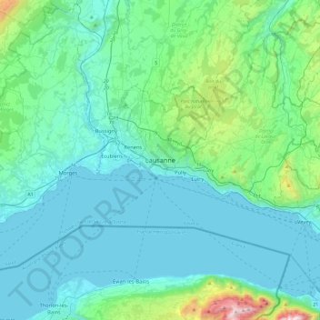
Naam: Topografische kaart Lausanne, hoogte, reliëf.
Locatie: Lausanne, District de Lausanne, Vaud, 1003, Switzerland (46.36183 6.47270 46.68183 6.79270)
Gemiddelde hoogte: 577 m
Minimale hoogte: 367 m
Maximale hoogte: 1.958 m
The most important geographical feature of the area surrounding Lausanne is Lake Geneva (Lac Léman in French). Lausanne is built on the southern slope of the Swiss plateau, with a difference in elevation of about 500 metres (1,640 ft) between the lakeshore at Ouchy and its northern edge bordering Le Mont-sur-Lausanne and Épalinges. Lausanne boasts a dramatic panorama over the lake and the Swiss and Savoyan Alps.