
Topografische kaart Mangalagiri
Interactieve kaart
Klik op de kaart om de hoogte weer te geven.
Over deze kaart
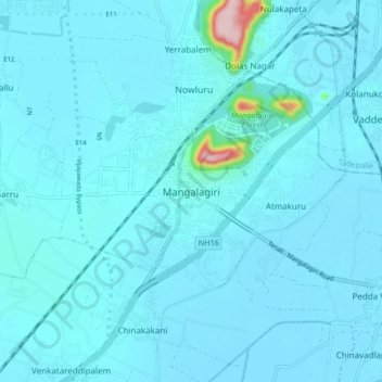
Naam: Topografische kaart Mangalagiri, hoogte, reliëf.
Locatie: Mangalagiri, Guntur, Andhra Pradesh, 522500, India (16.39182 80.52881 16.47182 80.60881)
Gemiddelde hoogte: 29 m
Minimale hoogte: 15 m
Maximale hoogte: 245 m
Mangalagiri is located at 16°26′N 80°33′E / 16.43°N 80.55°E / 16.43; 80.55. It has an average elevation of 29.08 m (95.4 ft).It is located 26 kilometres (16 mi) north east of the district headquarters, Guntur, and just 10 km (6.2 mi) south west of Vijayawada and also 30 km (19 mi) to the north west of Tenali by road. It lies on hilly terrain. It falls under Seismic Zone 3.