Topografische kaart Oshtoran Kuh
Interactieve kaart
Klik op de kaart om de hoogte weer te geven.
Over deze kaart
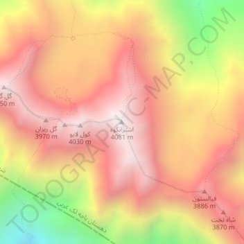
Naam: Topografische kaart Oshtoran Kuh, hoogte, reliëf.
Gemiddelde hoogte: 3.605 m
Minimale hoogte: 2.824 m
Maximale hoogte: 4.069 m

Klik op de kaart om de hoogte weer te geven.
Naam: Topografische kaart Oshtoran Kuh, hoogte, reliëf.
Gemiddelde hoogte: 3.605 m
Minimale hoogte: 2.824 m
Maximale hoogte: 4.069 m