Geolokaliseren

Topografische kaart Observatory Hill

Interactieve kaart

Klik op de kaart om de hoogte weer te geven.

Over deze kaart

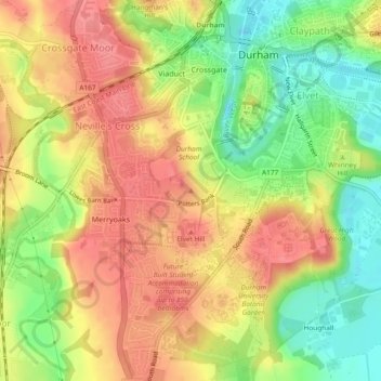
Naam: Topografische kaart Observatory Hill, hoogte, reliëf.

Locatie: Observatory Hill, Durham, County Durham, North East, England, DH1 4SZ, United Kingdom (54.76734 -1.58399 54.76744 -1.58389)

Gemiddelde hoogte: 73 m

Minimale hoogte: 29 m

Maximale hoogte: 107 m

Andere topografische kaarten

Klik op een kaart om zijn topografie, zijn hoogte en zijn reliëf te bekijken.

City of Durham

United Kingdom > England > County Durham > Durham

City of Durham, Durham, County Durham, North East, England, United Kingdom

Gemiddelde hoogte: 76 m

Pelton Fell

United Kingdom > England > County Durham > Durham

Pelton Fell, Durham, County Durham, North East, England, DH2 2QA, United Kingdom

Gemiddelde hoogte: 76 m

Flass Vale Local Nature Reserve

United Kingdom > England > County Durham > Durham

Flass Vale Local Nature Reserve, Durham North End Allotments, City of Durham, Durham, County Durham, North East, England, United Kingdom

Gemiddelde hoogte: 81 m

Houghall

United Kingdom > England > County Durham > Durham

Houghall, City of Durham, Durham, County Durham, North East, England, DH1 3SF, United Kingdom

Gemiddelde hoogte: 69 m