
Topografische kaart Sugar Loaf
Interactieve kaart
Klik op de kaart om de hoogte weer te geven.
Over deze kaart
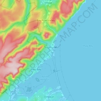
Naam: Topografische kaart Sugar Loaf, hoogte, reliëf.
Gemiddelde hoogte: 100 m
Minimale hoogte: -2 m
Maximale hoogte: 441 m
Andere topografische kaarten
Klik op een kaart om zijn topografie, zijn hoogte en zijn reliëf te bekijken.
St. Paul Island
Canada > Nova Scotia > Municipality of Victoria County
St. Paul Island, Municipality of Victoria County, Victoria County, Nova Scotia, Canada
Gemiddelde hoogte: 3 m
Old Fort Point
Canada > Nova Scotia > Municipality of Victoria County > Englishtown
Old Fort Point, Englishtown, Municipality of Victoria County, Victoria County, Nova Scotia, Canada
Gemiddelde hoogte: 32 m
Kidston Island Lighthouse
Canada > Nova Scotia > Municipality of Victoria County > Baddeck
Kidston Island Lighthouse, Baddeck Bay Road, Baddeck, Municipality of Victoria County, Victoria County, Nova Scotia, B0E 1B0, Canada
Gemiddelde hoogte: 11 m
Baddeck
Canada > Nova Scotia > Municipality of Victoria County
Baddeck, Municipality of Victoria County, Victoria County, Nova Scotia, B0E 1B0, Canada
Gemiddelde hoogte: 18 m