
Topografische kaart Wigmore
Interactieve kaart
Klik op de kaart om de hoogte weer te geven.
Over deze kaart
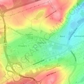
Naam: Topografische kaart Wigmore, hoogte, reliëf.
Gemiddelde hoogte: 118 m
Minimale hoogte: 52 m
Maximale hoogte: 183 m
Andere topografische kaarten
Klik op een kaart om zijn topografie, zijn hoogte en zijn reliëf te bekijken.
Newfound Pond
Canada > Newfoundland and Labrador > St. John's
Newfound Pond, St. John's, Newfoundland, Newfoundland and Labrador, Canada
Gemiddelde hoogte: 157 m
Cape Spear
Canada > Newfoundland and Labrador > St. John's
Cape Spear, St. John's, Newfoundland, Newfoundland and Labrador, Canada
Gemiddelde hoogte: 7 m
Cape Bay
Canada > Newfoundland and Labrador > St. John's
Cape Bay, St. John's, Newfoundland, Newfoundland and Labrador, Canada
Gemiddelde hoogte: 21 m
Signal Hill National Historic Site
Canada > Newfoundland and Labrador > St. John's
Signal Hill National Historic Site, 230, Quidi Vidi, Churchill Park, St. John's, Newfoundland and Labrador, Canada
Gemiddelde hoogte: 29 m
Blackhead
Canada > Newfoundland and Labrador > St. John's > Blackhead
Blackhead, St. John's, Newfoundland and Labrador, Canada
Gemiddelde hoogte: 48 m