
Topografische kaart Shrewsbury
Klik op de kaart om de hoogte weer te geven.
Shrewsbury
Shrewsbury is about 14 miles (23 km) west of Telford, 43 miles (69 km) west of Birmingham and the West Midlands Conurbation, and about 153 miles (246 km) north-west of the capital, London. More locally, the town is to the east of Welshpool, with Bridgnorth and Kidderminster to the south-east. The border with Wales is 9 miles (14 km) to the west. The town centre is partially built on a hill whose elevation is, at its highest, 246 feet (75 m) above sea level. The longest river in the UK, the River Severn, flows through the town, forming a meander around its centre. The town is subject to flooding from the river.
Over deze kaart
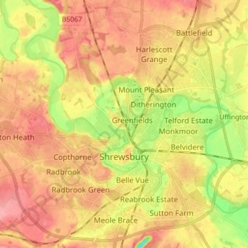
Naam: Topografische kaart Shrewsbury, hoogte, reliëf.
Locatie: Shrewsbury, Shropshire, England, United Kingdom (52.68019 -2.82004 52.75498 -2.70122)
Gemiddelde hoogte: 69 m
Minimale hoogte: 19 m
Maximale hoogte: 103 m
Andere topografische kaarten
Klik op een kaart om zijn topografie, zijn hoogte en zijn reliëf te bekijken.
Minton
United Kingdom > England > Shropshire > Church Stretton > Little Stretton
Gemiddelde hoogte: 272 m