
Topografische kaart Yavapai County
Interactieve kaart
Klik op de kaart om de hoogte weer te geven.
Over deze kaart
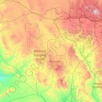
Naam: Topografische kaart Yavapai County, hoogte, reliëf.
Locatie: Yavapai County, Arizona, United States of America (33.88216 -113.33448 35.53065 -111.46127)
Gemiddelde hoogte: 1.433 m
Minimale hoogte: 345 m
Maximale hoogte: 3.757 m
The county's topography makes a dramatic transition from the lower Sonoran Desert to the south to the heights of the Coconino Plateau to the north, and the Mogollon Rim to the east. The highest point above sea level (MSL) in Yavapai County is Mount Union at an elevation of 7,979 ft (2,432 m) and the lowest is Agua Fria River drainage, now under Lake Pleasant.
Andere topografische kaarten
Klik op een kaart om zijn topografie, zijn hoogte en zijn reliëf te bekijken.
Grand Canyon Village
United States of America > Arizona > Grand Canyon Village
Grand Canyon Village, Coconino County, Arizona, United States of America
Gemiddelde hoogte: 1.764 m
Sunnycove Dam
United States of America > Arizona > Wickenburg
Sunnycove Dam, Wickenburg, Maricopa County, Arizona, 85390, United States of America
Gemiddelde hoogte: 660 m
Pinal County
United States of America > Arizona
Pinal County, Arizona, United States of America
Gemiddelde hoogte: 729 m
Maricopa County
United States of America > Arizona
Maricopa County, Arizona, United States of America
Gemiddelde hoogte: 549 m
Apache County
United States of America > Arizona
Apache County, Arizona, United States of America
Gemiddelde hoogte: 1.926 m
Gila County
United States of America > Arizona
Gila County, Arizona, United States of America
Gemiddelde hoogte: 1.362 m